Cargando...
Recursos educativos
-
Nivel educativo
-
Competencias
-
Tipología
-
Idioma
-
Tipo de medio
-
Tipo de actividad
-
Destinatarios
-
Tipo de audiencia
-
Creador
-
Around the world
Tiching explorer Organización
- 3495 visitas
This lesson we learn about sailing in the past: what ships they used, how stars were used to navigate, what kind of maps they used, the tasks of the crew, etc... There are comprehension questions. We…
-
Wildlife and habitats
Tiching explorer Organización
- 1 lo usan
- 3951 visitas
In this website we find out about animals (amphibians, birds, bugs, dinosaurs, fish, invertebrates, mammals, reptiles) and habitats (antarctic, artic, forest, water, grassland, mountain). There are…
-

Anticyclones and depressions
EduBook Organización
- 2093 visitas
Isobars are imaginary lines that appear on weather maps. They connect places with the same atmospheric pressure. Anticyclones are shown by concentric isobars, with high numbers at their centre.…
-

What is atmospheric pressure?
EduBook Organización
- 2082 visitas
Air has weight, even though it is very light. The atmosphere is a layer of air. The weight of this air applies pressure on the Earth's surface. Atmospheric pressure is not the same everywhere on the…
-

Average annual rainfall
EduBook Organización
- 1997 visitas
Precipitation maps have imaginary lines called isohyets. The isohyets connect places on the Earth's surface with the same amount of precipitation. The map shows how: Precipitation is abundant in…
-
-
Directions
INTEF Organización
- 2 lo usan
- 2027 visitas
In this unit we ask for and give directions, follow maps, and describe a journey in London. We practice grammar (present perfect, degrees of certainty, modals, third conditional, simple present and…
-
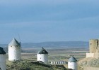
Travel routes in Spain: The Windmills Route. The Toledo area of La Mancha in
V&V Books Vicens Vives Organización
- 1825 visitas
Spain.info in english. Information about the travel route The Windmills Route. The Toledo area of La Mancha in Spain on the official website for tourism in Spain: destinations on the route The Windmills…
-

Learn. Reading a topographic map
EduBook Organización
- 1446 visitas
Topographic maps show the geographical relief of an area. Below is an example map (scale 1:25000) showing Matamorosa in Cantabria. Map reading guide The map key Look at the map key. Only the important…
-

Internet Project
EduBook Organización
- 1401 visitas
In the original version of Gulliver’s Travels, Jonathan Swift printed maps to show where the imaginary islands of Lilliput and Blefuscu were. He did this to make his book seem more realistic. At the…


Te estamos redirigiendo a la ficha del libro...
